
₹1648
₹1945
15.27% OFF
(All inclusive*)
Hardback
Delivery Options
Please enter pincode to check delivery time.
*COD & Shipping Charges may apply on certain items.
Review final details at checkout.
Looking to place a bulk order? SUBMIT DETAILS
Delivery Options
Please enter pincode to check delivery time.
*COD & Shipping Charges may apply on certain items.
Review final details at checkout.
About The Book
Description
Author
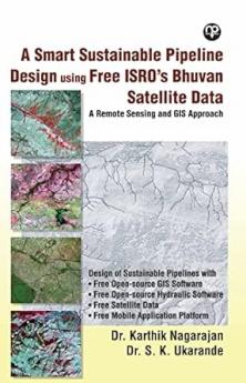
In this study the Indian Institute of Remote Sensing Indian Space Research Organisation (I.I.R.S. I.S.R.O.) Dehradun India supported by giving a platform for understanding remote sensing and G.I.S. and providing Spatial Satellite data of the study area through its web portal Bhuvan. City and Industrial Development Corporation (C.I.D.C.O.) supported providing nonspatial data of the study area such as Land Use Land Cover (L.U.L.C.) maps and population details. In contrast the toposheet of the study area was obtained from the Survey of India (S.O.I.) Dehradun.

Piracy-free

Assured Quality

Secure Transactions

Fast Delivery

Sustainably Printed
Details
ISBN 13
9781956861198
Publication Date
-30-07-2022
Pages
-227
Weight
-402 grams
Dimensions
-152.4x228.6x13.71 mm
