


English


Paperback
₹3874
₹4099
5.49% OFF
(All inclusive*)
Delivery Options
Please enter pincode to check delivery time.
*COD & Shipping Charges may apply on certain items.
Review final details at checkout.
Looking to place a bulk order? SUBMIT DETAILS
Delivery Options
Please enter pincode to check delivery time.
*COD & Shipping Charges may apply on certain items.
Review final details at checkout.
About The Book
Description
Author
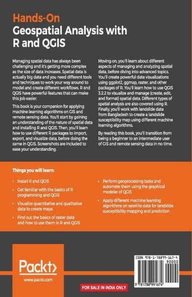
Practical examples with real-world projects in GIS Remote sensing Geospatial data management and Analysis using the R programming language//Key Features//Understand the basics of R and QGIS to work with GIS and remote sensing dataLearn to manage manipulate and analyze spatial data using R and QGISApply machine learning algorithms to geospatial data using R and QGISBook Description//Managing spatial data has always been challenging and it's getting more complex as the size of data increases. Spatial data is actually big data and you need different tools and techniques to work your way around to model and create different workflows. R and QGIS have powerful features that can make this job easier.//This book is your companion for applying machine learning algorithms on GIS and remote sensing data. You'll start by gaining an understanding of the nature of spatial data and installing R and QGIS. Then you'll learn how to use different R packages to import export and visualize data before doing the same in QGIS. Screenshots are included to ease your understanding.//Moving on you'll learn about different aspects of managing and analyzing spatial data before diving into advanced topics. You'll create powerful data visualizations using ggplot2 ggmap raster and other packages of R. You'll learn how to use QGIS 3.2.2 to visualize and manage (create edit and format) spatial data. Different types of spatial analysis are also covered using R. Finally you'll work with landslide data from Bangladesh to create a landslide susceptibility map using different machine learning algorithms.//By reading this book you'll transition from being a beginner to an intermediate user of GIS and remote sensing data in no time./ What you will learn//Install R and QGISGet familiar with the basics of R programming and QGISVisualize quantitative and qualitative data to create mapsFind out the basics of raster data and how to use them in R and QGISPerform geoprocessing tasks and automate them using the graphical modeler of QGISApply different machine learning algorithms on satellite data for landslide susceptibility mapping and predictionWho this book is for:/���This book is great for geographers environmental scientists statisticians and every professional who deals with spatial data. If you want to learn how to handle GIS and remote sensing data then this book is for you. Basic knowledge of R and QGIS would be helpful but is not necessary./

Piracy-free

Assured Quality

Secure Transactions

Fast Delivery

Sustainably Printed
Details
ISBN 13
9781788991674
Publication Date
-30-11-2018
Pages
-354
Weight
-619 grams
Dimensions
-191x235x18.79 mm
