
English


Paperback
₹4216
₹4499
6.29% OFF
(All inclusive*)
Delivery Options
Please enter pincode to check delivery time.
*COD & Shipping Charges may apply on certain items.
Review final details at checkout.
Looking to place a bulk order? SUBMIT DETAILS
Delivery Options
Please enter pincode to check delivery time.
*COD & Shipping Charges may apply on certain items.
Review final details at checkout.
About The Book
Description
Author
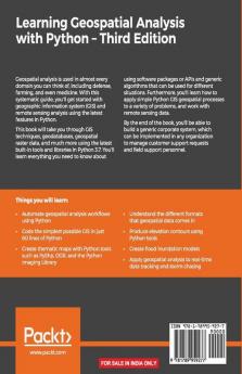
Learn the core concepts of geospatial data analysis for building actionable and insightful GIS applicationsKey FeaturesCreate GIS solutions using the new features introduced in Python 3.7Explore a range of GIS tools and libraries such as PostGIS QGIS and PROJLearn to automate geospatial analysis workflows using Python and JupyterBook DescriptionGeospatial analysis is used in almost every domain you can think of including defense farming and even medicine. With this systematic guide you'll get started with geographic information system (GIS) and remote sensing analysis using the latest features in Python.This book will take you through GIS techniques geodatabases geospatial raster data and much more using the latest built-in tools and libraries in Python 3.7. You'll learn everything you need to know about using software packages or APIs and generic algorithms that can be used for different situations. Furthermore you'll learn how to apply simple Python GIS geospatial processes to a variety of problems and work with remote sensing data.By the end of the book you'll be able to build a generic corporate system which can be implemented in any organization to manage customer support requests and field support personnel.What you will learnAutomate geospatial analysis workflows using PythonCode the simplest possible GIS in just 60 lines of PythonCreate thematic maps with Python tools such as PyShp OGR and the Python Imaging LibraryUnderstand the different formats that geospatial data comes inProduce elevation contours using Python toolsCreate flood inundation modelsApply geospatial analysis to real-time data tracking and storm chasingWho this book is forThis book is for Python developers researchers or analysts who want to perform geospatial modeling and GIS analysis with Python. Basic knowledge of digital mapping and analysis using Python or other scripting languages will be helpful. About the Author Joel Lawhead is a PMI-certified Project Management Professional a certified GIS Professional and the Chief Information Officer of NVision Solutions Inc. an award-winning firm specializing in geospatial technology integration and sensor engineering for NASA FEMA NOAA the US Navy and many other commercial and non-profit organizations. Joel began using Python in 1997 and started combining it with geospatial software development in 2000. He has authored multiple editions of Learning Geospatial Analysis with Python and QGIS Python Programming Cookbook both from Packt. He is also the developer of the open source Python Shapefile Library (PyShp) and maintains a geospatial technical blog GeospatialPython and Twitter feed @SpatialPython.

Piracy-free

Assured Quality

Secure Transactions

Fast Delivery

Sustainably Printed
Details
ISBN 13
9781789959277
Publication Date
-27-09-2019
Pages
-456
Weight
-791 grams
Dimensions
-191x235x24.03 mm
