

English



₹7560
(All inclusive*)
Paperback
Delivery Options
Please enter pincode to check delivery time.
*COD & Shipping Charges may apply on certain items.
Review final details at checkout.
Looking to place a bulk order? SUBMIT DETAILS
Delivery Options
Please enter pincode to check delivery time.
*COD & Shipping Charges may apply on certain items.
Review final details at checkout.
About The Book
Description
Author
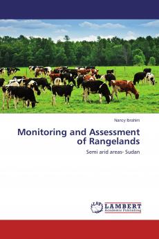
Different rangelands have different characteristics as indicated by soil features and vegetation patterns. These differences can be identified using remote sensing methods. The process based on using these differences as a base for remote sensing identification at different sites. Differentiation considered both spatial and temporal variations and hence data for different sites and times were used to achieve this. Since remote sensing can be used to distinguish between different characteristics of range sites then could be used to assess and monitor rangeland in semi arid areas. Successful identification will help for assessment and monitoring large rangelands based on this principle. Justification is that terrestrial measurements and assessment for vast rangelands areas always require extensive efforts and high cost. Quantitative factors like biomass alone are not enough therefore more than one indicator were used like soil features and topographic features.

Piracy-free

Assured Quality

Secure Transactions

Fast Delivery

Sustainably Printed
Details
ISBN 13
9783659517037
Publication Date
-05-04-2015
Pages
-160
Weight
-215 grams
Dimensions
-150x220x8.82 mm
