
English


Paperback
₹5181
₹6386
18.87% OFF
(All inclusive*)
Delivery Options
Please enter pincode to check delivery time.
*COD & Shipping Charges may apply on certain items.
Review final details at checkout.
Looking to place a bulk order? SUBMIT DETAILS

Piracy-free

Assured Quality

Secure Transactions
About The Book
Description
Author
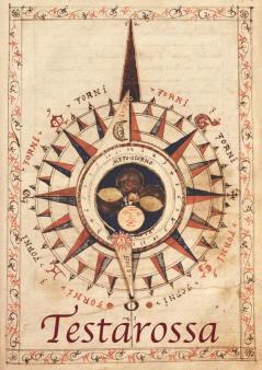
<p>In the latter years of Queen Mary&#39;s short and turbulent reign in the mid-sixteenth century England was still on the cusp of acquiring the reputation as a great sea faring nation that would come in the Elizabethan era. Into the hotbed of religious and political turmoil that was England at this time came a gentleman of possibly Italian lineage. How he came to be in London and for what reason he produced this work we are not sure. What we do know however is that he created a visually stunning and technically brilliant navigation manual of which we believe this to be the only version in existence.A fascinating insight into the perspective of the physical world at that time the manuscript has been analysed and a commentary produced in both English and Italian by Richard Pflederer Fellow of the RGS-IBG and a worldwide authority on portolan charts and navigational science. Produced in full colour this reproduction is a &#39;must-have&#39; for anyone interested in the study of navigational history or simply for the lay person as a beautifully produced window into times past.As Francis Herbert former Curator of Maps at the RGS-IBG and under whose aegis this facsimile was created comments; &#39;a long way from one handwritten work of 1557 to a scanned copy available to all in 2007&#39;.</p>
Piracy-free
Assured Quality
Secure Transactions
Delivery Options
Please enter pincode to check delivery time.
*COD & Shipping Charges may apply on certain items.
Review final details at checkout.
Details
ISBN 13
9781905748587
Publication Date
-16-11-2016
Pages
-146
Weight
-373 grams
Dimensions
-210x297x10.08 mm
