English


Paperback
₹5317
₹5836
8.89% OFF
(All inclusive*)
Delivery Options
Please enter pincode to check delivery time.
*COD & Shipping Charges may apply on certain items.
Review final details at checkout.
Looking to place a bulk order? SUBMIT DETAILS
Delivery Options
Please enter pincode to check delivery time.
*COD & Shipping Charges may apply on certain items.
Review final details at checkout.
About The Book
Description
Author
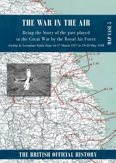
<p><span style=color: rgba(0 0 0 1)>A series of 28 Ordnance Survey maps that are overlaid to show the path taken by German Zeppelins &amp; Aircraft during air raids over England. Of immense value to both the Great War air historian and local history expert. This volume covers AIRSHIP RAIDS from 16-17 March 1917 to 29.&nbsp;5-6 August 1918 &amp; AEROPLANE RAIDS from 25 May 1917 to 19-20 May 1918. Zeppelin tactical numbers are shown - Aircraft types and how many are also shown along with weather information number of bombs dropped casualties - both killed and wounded - and interestingly monetary damage.</span></p><p><span style=color: rgba(0 0 0 1)>Published&nbsp;in c1935 separately to the 7 volumes of the official War In The Air text volumes and folded within in a map case to be more practical and convenientwhilst not impeding the easy referencing of the smaller format of the text volumes - now reprinted in book form both as key map with segmented sheets all reproduced in Full colour facsimile.</span></p><p><br></p><p><br></p>

Piracy-free

Assured Quality

Secure Transactions
Details
ISBN 13
9781474540049
Publication Date
-10-06-2024
Pages
-212
Weight
-528 grams
Dimensions
-210x297x14.63 mm
